Thursday, February 19, 2009

TAMAN NASIONAL LAUT KEPULAUAN KARIMUNJAWA


Kawasan ini terletak di laut Jawa + 83 km dari Kota Jepara menuju arah utara. Obyek ini merupakan kepulauan yang ditetapkan sebagai Taman Nasional laut Karimunjawa. luas daratan 7.120 Ha dengan pulau berjumlah 27 buah, namun yang berpenghuni hanya 5 buah. yaitu Karimunjawa, Kemujan, Parang, Nyamuk dan Genting. dengan hamparan pemandangan di sela-sela pulau, pasir putih yang membentang di sepanjang pantai dengan pohon kelapa. Terdapat 242 jenis ikan hias, serta 133 genera fauna akuatik. Dengan kapal motor, karimun jawa dapat ditempuh dalam waktu sekitar 5 jam dari dermaga Jepara. Di kawasan Taman Nasional laut ini juga telah dibangun "Kura-Kura Resort" yang merupakan kawasan peristirahatan dengan fasilitas lux, yang merupakan milik investor asing.


Secara garis besar fauna yang ada di Kepulauan Karimunjawa terdiri dari 2 (dua ) kelompok, yaitu :
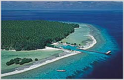
1. Daratan : Rusa, Trenggiling, Landak, Ular, Bangau Tong tong, Bangau Abu-abu, Elang laut dan Wedi-wedi. Burung elang laut merupakan satwa langka yang dapat dijumpai di kepulauan ini.
2. Perairan : Terumbu karang, spons, karang lunak, akar bahar, kerang merah, penyu dan ikan hias. Pantai-pantai di Karimunjawa sebagian besar berpasir putih, oleh karena itu cocok untuk kegiatan berjemur, menyelam dan memancing.

Kegiatan wisata yang dapat dilakukan di Karimunjawa :
1. Olah raga selam, bagi yang hobi menyelam dapat menyalurkan hobinya di Tanjung Gelam ( di Karimunjawa ), Pulau Menjangan Kecil dan Pulau Cemara Kecil.
2. Mandi di Pantai dan Berjemur, cocok dilakukan di Pulau Menjangan Besar yang berpasir putih dan Pulau Cemara Kecil.
3. Snorkeling, di berbagai spot yang memberikan pemandangan bawah laut yang mengagumkan.
4. Memancing, para hobiist mancing dapat menyalurkan hobinya dengan menyewa kapal.
5. Glass bottom boat, bagi yang tidak bisa berenang bisa menikmati keindahan bawah laut dng glass bottom boat.
6. Jetski dan banana boat, bagi yang menyukai olah raga air ini, dapat melakukannya di karimunjawa.
7. Penangkaran ikan hiu, mencoba merasakan fear factor disini, bercanda dengan hiu.
8. Berperahu mengunjungi pulau-pulau, banyaknya pulau-pulau yang indah, dapat anda kunjungi dengan menggunakan perahu.
9. Ziarah dimakam Sunan Nyamplungan.
10. Menyelami kehidupan tradisi nelayan Bugis dan Madura dng rumah khas panggungnya.

Menuju KARIMUNJAWA dapat ditempuh dengan kapal cepat Kartini I dari Semarang Setiap hari Sabtu dan Senin setiap 2 minggu sekali, dari Jepara setiap hari Senin 2 minggu sekali. Dng KM. Muria dari Jepara setiap hari Rabu dan Sabtu, dapat pula dng jalur penerbangan dari bandara A. Yani Semarang dengan pesawat charter jenis CASSA 212 sekitar 30 menit sampai bandara Dewadaru Karimunjawa. Telah tersedia sarana akomodasi yg cukup memadai mulai home stay, resort dan hotel

Legenda Nyamplungan

Nama Karimun menurut cerita rakyat setempat tidak terlepas dari sosok sunan Nyamplung, yang bernama asli Syech Amir Hasan, putera dari sunan Muria. Sedari kecil, ia hidup dimanja sehingga ketika beranjak dewasa, ia menjadi cenderung nakal. Sunan Muria sudah berusaha mendidik puteranya tersebut agar menjadi lebih baik, tetapi selalu gagal. Akhirnya sunan Muria menitipkan puteranya kepada sunan Kudus, dengan harapan menjadi lebih baik.

Di bawah bimbingan sunan Kudus, Amir Hasan memang menjadi pribadi yang lebih baik dan taat, sehingga ia dikembalikan kepada keluarganya. Tetapi setelah berkumpul kembali dengan keluarganya, perilaku Amir Hasan kembali seperti semula.

Sunan Muria merasa prihatin, dan akhirnya memerintahkan puteranya tersebut untuk turun gunung Muria dan mengamalkan ilmu agama di pulau yang nampak "kremun-kremun" (tidak jelas) bila dilihat dari gunung Muria. Dan sunan Muria pun mengatakan bahwa Amir Hasan tidak boleh kembali ke pulau Jawa sebelum tugasnya selesai.

Dengan berbekal 2 buah biji Nyamplung untuk ditanam di pulau tujuan, dan mustaka masjid (sampai saat ini masih berada di kompleks makam sunan Nyamplungan), serta ditemani oleh 2 orang abdi, akhirnya Amir Hasan pun memulai perjalannya. Setelah sampai dan menemukan tempat yang cocok untuk ditinggali, Amir Hasan kemudian menanam 2 buah biji Nyamplung yang dibawanya dari pulau Jawa. Tanaman yang tumbuh dari kedua biji Nyamplung inilah yang sekarang dikenal sebagai pohon Nyamplung, dan lokasinya diberi nama dukuh Nyamplung.

Friday, February 6, 2009

Kuta Bali


Kuta yang terletak di bagian selatan pulau Bali, merupakan salah satu cikal bakal perkembangan pariwisata Bali. Dulunya tempat ini merupakan perkampungan nelayan Bali dan seiring berkembangnya pariwisata Indonesia dan Bali khususnya, penduduk lokal mulai menyewakan rumah pribadi untuk disewakan sebagai tempat penginapan.

Sekarang kawasan Kuta telah berkembang menjadi ikon pariwisata Bali atau lebih dikenal dengan sebutan International city karena merupakan tempat bertemunya wisatawan dari seluruh dunia dan juga wisatawan lokal.

Dilihat dari segi fasilitas Kuta memiliki fasilitas yang lengkap. Penginapan atau hotel, restoran, spa dan pendukung pariwisata lainnya banyak ter dapat di sini.

Pantai Kuta merupakan tempat wisata yang banyak dipilih untuk menghabiskan liburan selama di Kuta. Pantai dengan pasir putih ini dipilih sebagai tempat olahraga surfing dan juga sangat cocok untuk tempat bersantai sambil menantikan indahnya sunset pantai Kuta. Tidak salah ribuan wisatawan selalu memadati pantai ini

Sekilas tentang Kuta.

Berbicara mengenai Kuta sebagai daerah tujuan wisata, ada baiknya kita tahu sedikit perkembangan kawasan ini.

1970-an

Tahun 1970-an kawasan ini berkembang sebagai koloni hippies, turis gembel yang datang dari seantero dunia dengan membawa gaya hidup bebas, mereka tinggal di rumah penduduk yang bernama pension.

1980-an

Tahun 1980-an, berkembang menjadi kawasan khusus untuk turis Australia yang berselancar. Hotel berbintang dan melati mulai masuk ke kawasan ini.

1990-an

Tahun 1990-an Kuta mengalami booming turis, Ribuan kamar selalu penuh dan penduduk mulai mengubah bagian depannya menjadi art shop mereka menjual bikini dan kaos oblong dengan harga murah.

Ngarai Sianok


Ngarai Sianok adalah sebuah lembah curam (jurang) yang terletak di jantung kota Bukittinggi, Sumatera Barat. Lembah ini memanjang dan berkelok dari selatan ngarai Koto Gadang sampai di Ngarai Sianok Enam Suku, dan berakhir sampai Palupuh. Ngarai Sianok memiliki pemandangan yang indah dan menjadi salah satu objek wisata utama provinsi.

Jurang ini dalamnya sekitar 100 m membentang sepanjang 15 km dengan lebar sekitar 200 m dan merupakan bagian dari patahan yang memsiahkan Pulau Sumatra menjadi dua bagian memanjang (Patahan Semangko). Patahan ini membentuk dinding yang curam, bahkan tegak lurus dan membentuk lembah yang hijau - hasil dari gerakan turun kulit bumi (sinklinal) - yang dialiri Sungai Sianok yang airnya jernih. Di zaman kolonial Belanda, jurang ini disebut juga sebagai kerbau sanget, karena banyaknya kerbau liar yang hidup bebas di dasar ngarai.

Sungai Sianok kini bisa diarungi dengan menggunakan kano dan kayak yg disaranai oleh suatu organisasi olahraga air "Qurays". Rute yang ditempuh adalah dari Desa Lambah sampai Desa Sitingkai Batang Palupuh selama kira-kira 3,5 jam. Di tepiannya masih banyak dijumpai tumbuhan langka seperti rafflesia dan tumbuhan obat-obatan. Fauna yang dijumpai misalnya monyet ekor panjang, siamang, simpai, rusa, babi hutan, macan tutul, serta tapir.

Danau Toba


Danau Toba
merupakan danau terbesar di Asia Tenggara. Danau terbentuk akibat erupsi Gunung Toba yang termasuk ke dalam salah satu erupsi terbesar sepanjang sejarah dunia. Danau Toba yang terletak di Pulau Sumatra ini tak hanya menjadi tujuan wisata lokal namun juga mancanegara.

Apa yang menarik
Pulau kecil di tengah-tengah Danau Toba yang dikenal dengan sebutan Pulau Samosir menjadi tempat yang tepat menikmati keindahan serta suasana alam yang indah. Bahkan Anda dapat menginap di cottage bergaya Batak dan merasakan kehidupan selayaknya mereka orang-orang Batak. Rumah tradisional yang terbuat dari kayu tentunya akan melengkapi pengalaman berlibur Anda.

Cara ke sana?
Menuju Medan Anda dapat menggunakan pesawat terbang, banyak maskapai penerbangan yang menawarkan tujuan ke kota Medan. Sementara dari Medan ke Danau Toba Anda dapat menyewa mobil atau men-carter taksi atau bis.

Sumber : Majalah Boulevard

Wednesday, February 4, 2009


Borobudur Sunrise, Pemandangan Matahari Terbit di Nirwana

Mengagumi kemegahan Borobudur di siang hari dan melihat detail setiap arca dan batu-batu berelief penyusunnya adalah sesuatu yang paling didambakan oleh jutaan orang dari berbagai negara. Namun, tak banyak orang yang menyadari bahwa Borobudur juga memiliki pemandangan unik lain, yaitu pemandangan matahari terbit yang indah dan menerpa tubuh stupa Sang Budha yang bersila di puncak candi yang berdiri sejak abad ke 9 ini.

Bila anda termasuk orang yang belum pernah menikmatinya, maka mencobanya untuk mewarnai datangnya kehidupan baru pada awal tahun tentu akan menjadi pengalaman tak terlupakan. Matahari yang terbit dengan sinar terang setidaknya bisa turut menyemangati anda menjalani kehidupan setahun ke depan, dan yang jelas bisa menjadi sebuah pengingat bahwa kebijaksanaan atau nirwana yang dilambangkan oleh puncak candi ini adalah tujuan utama hidup anda.

Untuk menikmati pemandangan matahari terbit itu, sejak sore hari anda bisa menginap di Hotel Manohara, satu-satunya hotel yang berada di kompleks Candi Borobudur. Atau, anda bisa juga mengikuti paket tur Borobudur Sunrise yang ditawarkan oleh beberapa agen tur. Tanpa itu, anda bahkan tak akan bisa masuk ke kompleks candi dan sunrise pun terlewatkan, sebab pintu gerbang masuk kawasan objek wisata ini baru dibuka sekitar pukul 7.30 WIB.

Bila menginap di Manohara, sebenarnya anda bisa berangkat naik ke Borobudur pada jam berapa pun untuk menikmati sunrise. Namun, pengelola hotel dan beberapa agen tur biasanya akan memberangkatkan anda pukul 3.30 pagi sehingga dapat berjalan santai dan tidak menunggu sunrise terlalu lama. Pemandangan sunrise sendiri biasanya akan bisa dinikmati sekitar pukul 5.00 pagi. Sebaiknya anda membawa jaket untuk mengalahkan hawa dingin dan bila perlu membawa senter untuk penerangan.

Begitu langit di timur tampak mulai terang, anda bisa bersiap untuk melihat gerak gerik matahari memunculkan diri. Sedikit saja sinar kuning kemerahan muncul, itu berarti saat fajar telah tiba di puncak Borobudur yang melambangkan nirwana ini. Sebuah keunikan ketika anda melihat sunrise di Borobudur adalah bahwa matahari seolah datang dari celah antara dua gunung, yaitu Merapi yang menjadi salah satu gunung teraktif di dunia dan Merbabu yang sering disebut kembarannya.

Saat Merapi tengah aktif mengeluarkan lava pijarnya dan kabut tak menutupi, anda bisa melihat guguran lava pijar yang menuju hulu Kali Krasak. Warna lava pijar yang merah membara akan tampak sangat terang, menjadi kontras dengan warna langit yang masih gelap. Januari 2006 lalu, puluhan wisatawan menikmati pemandangan ini dan di tengah aktivitas Merapi yang mulai meningkat akhir-akhir ini, anda tentu berpeluang untuk menikmatinya juga.

Pemandangan lain yang tak kalah menarik adalah desa-desa sekitar Borobudur yang akan tampak bila anda menatap ke bawah. Di desa-desa sekitar itulah, hingga kini pertanian dan kesenian tetap berkembang, setidaknya bisa membantu anda membayangkan kondisi desa sekitar saat candi ini didirikan. Bila kabut tebal sedang menyelimuti, anda masih bisa melihat pepohonan tinggi berwarna hijau yang muncul dari permukaan kabut.

Setiap gerak gerik matahari dapat direkam dari seberapa terang berkas sinar yang menerpa stupa Sang Budha. Kian tinggi matahari, stupa Sang Budha pun semakin terlihat terang, mengubah warna yang semula terlihat hitam menjadi abu-abu cerah. Bila memiliki kamera yang cukup bagus merekam gambar, anda bisa mengabadikan momen saat seberkas sinar matahari menerpa stupa Sang Budha dan membuat satu bagian stupa tersebut lebih terang dari bagian lain.

Saat panas matahari mulai menyengat, itulah saatnya anda mesti turun candi. Namun, jangan khawatir, anda masih bisa mengelilingi desa-desa sekitar Borobudur yang semula hanya bisa dilihat dari atas. Beberapa desa kini ditetapkan sebagai desa wisata. Anda bisa menyaksikan kesibukan penduduk bertani, membuat tembikar, memahat patung dan berbagai aktivitas lainnya. Kehadiran anda di desa itu setidaknya bisa memberi harapan bagi para penduduk yang kini kian sulit menjalani hidup.

Naskah: Yunanto Wiji Utomo
Artistik: Agung Sulistiono Mabruron
Copyright © 2006 YogYES.COM

Boko Sunrise


Boko Sunrise, Melihat Matahari Terbit dari Puncak Bukit Tugel

Telah banyak orang mengunjungi Istana Ratu Boko yang semula bernama Abhayagiri Vihara, sebuah istana yang berdasarkan artinya berada di bukit penuh kedamaian. Namun, sedikit saja yang pernah merasakan kenikmatan berjalan dari lokasi istana ini dan trekking menyusuri bukit Boko pada dini hari dan menyaksikan fajar menyingsing di ufuk timur. YogYES mengajak anda menikmatinya untuk merayakan datangnya fajar baru di awal tahun.

Untuk menikmatinya, anda bisa mendaftar sebagai peserta Boko Trekking di Taman Wisata Candi. Sekali mendaftar, anda mendapatkan paket wisata berupa keliling Istana Ratu Boko, menikmati pemandangan senja di Plasa Andrawina (salah satu bangsal istana), bermalam dalam tenda dan trekking menyusuri bukit Boko melihat pemandangan matahari terbit serta melihat candi-candi di kompleks Ratu Boko. Tentu sebuah paket wisata menyenangkan di akhir tahun.

Perjalanan paling menarik, yaitu trekking untuk kemudian menikmati pemandangan matahari terbit, biasanya dimulai sekitar pukul 3 dini hari. Waktu yang sangat tepat untuk memulai perjalanan melihat fajar di awal tahun karena pasti di jam-jam sebelumnya anda akan lebih disibukkan dengan ritual meniup terompet sebagai pertanda tahun baru telah tiba. Pastikan kondisi fisik anda cukup mampu untuk berjalan setelah begadang semalam.

Medan menuju Bukit Tugel, tempat anda akan menikmati salah satu fajar terindah, sebenarnya tidak begitu sulit sehingga anda tak perlu merasa khawatir. Di samping itu, pihak penyelenggara tour telah menyediakan pemandu sehingga akan memudahkan petualangan anda yang baru pertama mendaki bukit. Namun demikian, beberapa peralatan pribadi seperti baju lapangan, helm, sepatu gunung, senter dan obat-obatan tetap perlu disiapkan.

Selama perjalanan menuju Bukit Tugel, anda memang kurang dapat melihat panorama alam sekitar karena hari masih gelap, namun anda dapat mendengar musik alam yang syahdu. Jika peka, anda bahkan dapat mengetahui saat musik alam itu mulai berganti menjelang pagi tiba, suara serangga tanah dan burung malam yang semula mendominasi digantikan oleh kok ayam, suara burung gereja dan sedikit keramaian yang ditimbulkan oleh aktivitas warga sekitar.

Perjalanan menuju Bukit Tugel melelahkan akan berakhir saat menjelang fajar sehingga anda dapat beristirahat sejenak untuk menunggu sang mentari menampakkan diri. Sambil duduk, menikmati kopi atau teh hangat yang dibawa dari tenda dan bercakap dengan teman tentu akan menyenangkan. Berbicara tentang rencana satu tahun ke depan dalam hidup masing-masing dan membuka diri terhadap masukan tentu menjadi sangat berarti.

Panorama langit mengagumkan akan tampak saat menunggu fajar tiba. Warna hitam malam akan tergantikan dengan gradasi warna kuning ke merah. Semakin lama, warna kuning akan semakin dominan menandakan matahari sudah mulai tinggi. Bila matahari telah benar-benar menghiasi pagi, maka warna langit yang semula hitam akan berganti biru dengan dihiasi awan berwarna putih. Bila anda membawa kamera, tentu menyenangkan bisa merekam setiap perubahan itu.

Begitu matahari telah terlihat bulat di ujung timur, barulah anda bisa menyaksikan pemandangan alam sekitar Bukit Tugel yang tak kalah mengagumkan. Menatap ke arah utara, anda bisa melihat Gunung Merapi yang berdiri kokoh di utara dengan bentukan serupa asap putih dari puncak gunungnya. Masih di arah utara, anda juga bisa melihat kegagahan Candi Prambanan yang menjadi candi Hindu tercantik.

Di arah lain, anda bisa melihat pemandangan kota Yogyakarta, persawahan dan pedusunan di sekitar bukit itu, beberapa candi yang terletak lebih di bawah, dan pemandangan menarik lainnya. Anda juga dibebaskan untuk menelusuri setiap sudut di Bukit Tugel itu. Setelah itu, anda akan berjalan pulang ke lokasi menginap semalam sambil menikmati pemandangan di kanan kiri trek menuju bukit Tugel.

Penulis: Yunanto Wiji Utomo
Artistik: Agung Sulistiono Mabruron
Copyright © 2006 YogYES.COM

Tuesday, February 3, 2009

Papua

PAPUA
Papua is one of Indonesia province comprising a majority part of the western half of New Guinea Island and nearby. The province originally covered the entire western half of New Guinea, but in 2003, the western portion of the province, on the Bird's Head Peninsula, was declared in Jakarta as separate province named West Irian Jaya. The legality of this separation has been disputed, as it appears to conflict with the conditions of the Special Autonomy status awarded to Papua in the year 2000. The status of West Irian Jaya province is not yet resolved as of early 2006.

Papua is the official Indonesian and internationally recognized name for the province. During the colonial era the region was known as Dutch New Guinea. The province was known as West Irian or Irian Barat from 1969 to 1973, and then renamed Irian Jaya ("Victorious Irian") by Soeharto. This was the official name until Papua was adopted in 2002. Today, natives of this province prefer to call themselves Papuans rather than Irianese. This may be due to etymology (variously identified as a real etymology or a folk etymology) the name of Irian, which stems from the acronym Ikut Republik Indonesia, Anti Nederland (join/follow with the Republic of Indonesia, rejecting The Netherlands). The name West Papua is used among Papuan separatists and usually refers to the whole of the Indonesian portion of New Guinea.

The capital of Papua province is Jayapura. Most of the population depends on subsistence farming, especially the cultivation of rice and maize. The main industries include copper (with the largest concentration of copper in the world at Tembagapura), palm oil, copra, maize, groundnuts, pepper, tuna, gold, oil, coal, and phosphates. It is mostly a mountainous and forested region, with the Maoke Mountain range rising to 5,029-m/16,499 ft at Jaya Peak. The population comprises Melanesians (original settlers of Western New Guinea), Papuans, Negritos, and Europeans. Indigenous animism prevails. The province declared independence from Indonesia, as West Papua, in June 2000. However, the president of Indonesia stated that the declaration was unrepresentative of true feeling in the province.

Geographically
A central East-West mountain range dominates the geography of New Guinea, over 1600 km in total length. The western section is around 600 km long and 100 km across. Steep mountains 3000 to 4000 m and up to 5000 m high along the range ensure a steady supply of rain from the tropical atmosphere. The tree line is around 4000 m elevation and the tallest peaks are snowbound year round.

Both North and West of the central ranges the land remains mountainous mostly 1000 to 2000 m high covered by thick rain forest and a warm humid year round climate. The third major habitat feature is the southeast lowlands with extensive wetlands stretching for hundreds of kilometers.
Mamberamo River sometimes referred to the "Amazon of Papua" is the province's largest river, which winds through the northern part of the province. The result is a large area of lakes and rivers known as the Lakes Plains region. The famous Baliem Valley, home of the Dani people is a tableland 1600 m above sea level in the midst of the central mountain range; Jaya Peak, sometimes known by its former Dutch name Carstensz Pyramid, is a mist covered limestone mountain peak 5030 m above sea level.

Wide Area
The wide area of Papua is 420,000 sq km/162,000 sq mi.

Population
Papua population based on 2000 est. is 2,220,900. It has some 240 different tribal peoples, each with its own language and culture. Indigenous Papuans in West Papua and Papua New Guinea speak some 15% of the world's known languages. West Papua together with the rest of the island of New Guinea, are the lungs of the Asia-Pacific, containing the last great surviving virgin rainforest after the Amazon.

Demographics
The population of Papua province and the neighboring West Irian Jaya, both of which are still under a united administration, totaled 2,646,489 in 2005. Since the early 1990s, Papua has had the highest population growth rate of all Indonesian provinces at over 3% annually. This is partly a result of high birth rates, but also from immigration from other regions in Indonesia.

According to the 2000 census, 78% of the Papuan population identified themselves as Christian with 54% being Protestant and 24% being Catholic. 21% of the population was Muslim and less than 1% were Buddhist or Hindu. There is also substantial practice of animism by Papuans, which is not recorded by the Indonesian government in line with the policy of Pancasila.

Ecology
A vital tropical rainforest with the tallest tropical trees and vast biodiversity, Papua's known forest fauna includes marsupials (including possums, wallabies, tree-kangaroos, cuscuses), other mammals (including the endangered Long-beaked Echidna), many bird species (including birds of paradise, cassowaries, parrots, cockatoos), the world's longest lizards (Papua monitor) and the world's largest butterflies. The island has an estimated 16,000 species of plant, 124 genera of which are endemic.
The extensive waterways and wetlands of Papua are also home to salt and freshwater crocodile, tree monitor, flying foxes, osprey, bats and other animals; while the equatorial glacier fields remain largely unexplored.

In February 2006, a team of scientists exploring the Foja Mountains, Sarmi, discovered numerous new species of birds, butterflies, amphibians, and plants, including a species of rhododendron, which may have the largest bloom of the genus. Ecological threats include logging-induced deforestation, forest conversion for plantation agriculture (especially oil palm), small holder agricultural conversion, the introduction and potential spread of non-native alien species such as the Crab-eating Macaque, which preys on and competes with indigenous species, the illegal species trade, and water pollution from oil and mining operations.

Regions
Indonesia structures regions contains of regencies and sub districts within those. Though names and areas of control of these regional structures can vary over time in accord with changing political and other requirements, in 2005 Papua province consisted of 19 regencies. The regencies are: Timika, Yapen - Waropen, Biak - Numfor, Nabire, Puncak Jaya, Paniai, Jayawijaya, Merauke, Sarmi, Keerom, Waropen, Tolikara, Yahukimo, Bintang Mountain, Boven Digoel, Mappi, Asmat, Supiori, and Jayapura. In addition to these, Jayapura city also has the status of regency.

Government
Papua province has governed by a directly elected governor (currently Barnabas Suebu) and a regional legislature, DPRP (Dewan Perwakilan Rakyat Papua). A unique government organization that only exists in Papua is the MRP (Majelis Rakyat Papua / Papuan People's Council) that was formed by the Indonesian Government in 2005 as a coalition of Papuan tribal chiefs, tasked with arbitration and speaking on behalf of Papuan tribal customs.

Irian Barat

WEST IRIAN JAYA


Irian Jaya is a tropical island with primeval rain forests, powerful rivers, beautiful beaches, lakes, and mountains. The highest mountain is Mount Jayawijaya, with snowcaps covering its 5,000-meter-high peaks. The area is also rich in natural resources, including fish, timber, and precious metals. These, however ever, have become a source of conflict between the central government and local peoples.

West Irian Jaya is a hot, humid island rising from the sea with some of the most impenetrable jungles in the world and yet also has snowcaps covering 5,000meter - High Mountain peaks, towering over glacier lakes. West Irian Jaya is Indonesia's largest and easternmost province and covers the western half of the world's second largest island. It is a land of exceptional natural grandeur, with beautiful scenic beaches, immense stretches of marshlands, cool grassy meadows and powerful rivers carving gorges and tunnels through dark and dense primeval forests. The most heavily populated and cultivated parts of the island are the Paniai Lakes district and the Baliem Valley to the east.

The people of the island can be divided into more than 250 subgroup, which are closely related to the islands along the southern rim of the Pacific and include among others, the Marindanim, Yah'ray, Asmat, Mandobo, Dani and Afyat. Those in the central highlands still maintain their customs and traditions and because of the terrain have virtually been untouched by outside influences. Communications hove always been difficult here and different tribes have lived, for the most part, in isolation even of each other, resulting in an incredibly diverse mixture of cultures.

POPULATION
The province has a population of approximately 800,000, making it one of the least populous of all Indonesian provinces. The capital of Irian Jaya Barat is Manokwari. The most populated and cultivated parts of the island are Paniai Lake district and Baliem Valley to the east. The population comprises migrants from Java and indigenous people from diverse tribes, such as Dani of Baliem Valley in the central highlands, Asmat of the southern coastal region, and Ekari of Wissel Lakes region. The official language is Indonesian, but the indigenous people, reflecting the isolation and small numbers of the tribes, speak at least 250 languages.

GOVERNMENT ADMINISTRATION
The province contains one city, Sorong, and 8 regencies:

  • Manokwari
  • Fak Fak
  • Sorong Selatan with its capital is Teminabuan
  • Raja Ampat with its capital is Waisai
  • Kaimana
  • Bintuni Bay with its capital is Bintuni
  • Wondama Bay with its capital is Rasiei
  • Sorong Regency
  • Sorong city

Maluku Utara

NORTH MALUKU

North Maluku is a province of Indonesia. It covers the northern part of Maluku Islands, which are split between it and Maluku Province. Maluku Province used to cover the entire group. The planned provincial is Sofifi, on Halmahera, but the current capital and largest population is Ternate Island. So, the capital of North Maluku is Ternate.

In the sixteenth and seventeenth century, the islands of North Maluku were the original "Spice Islands". At the time, the region was the sole source of cloves. The Dutch, Portuguese, Spanish, and local kingdoms including Ternate and Tidore fought each other for control of the lucrative trade in these spices. Nutmeg trees have since been transported and replanted all around the world and the demand for nutmeg from the original spice islands has ceased, greatly reducing North Maluku's international importance.

In North Maluku the land makes up just 15 percent of the area's total surface. In many places the surrounding seas could be thousands of meters deep. North Maluku is in a transition zone between the Asian and Australian fauna and flora, and also between the Malay-based cultures of western Indonesia and those of Melanesia.

A great variety of endemic plant and animal species are found in the rugged forest-covered and mountainous hinterlands of most of the islands. A few of the best known are the Rucker-tailed Kingfisher, the Red-crested Moluccan Cockatoo and various brilliantly colored lorikeets and parrots.

North Maluku sits astride one of the world's most volatile volcanic belts. The region has known more than 70 eruptions in the last 400 years. Tremors and volcanic eruptions are by no means rare events at present. Many islands, in fact, look from a distance like volcanic cones rising right out of the sea.

TRANSPORTATION
Air and sea transportation are the main means, which link the islands together. Good roads on the islands provide easy access to the often-remote places of interest.

CLIMATE
There are two seasons that are suitable for sailing to these islands: February-March and October-November, when the wind and the waves are low.

GEOGRAPHICALLY
The boundaries of North Maluku is:
East Side: Halmahera Sea
West Side: Maluku Sea
North Side: Pacific Ocean
South Side: Seram Sea

WIDE AREA
The wide area of North Maluku Region is 164.370,12 Km2.

DEMOGRAPHY
The population of North Maluku is 870,000 (according to the National Socio-Economic Survey, 2004, making it the least populous province in Indonesia. The Tribes are: Module, Pagu, Ternate, Makian Barat, Kao, Tidore, Buli, Patani, Maba, Sawai, Weda, Gne, Makian Timur, Kayoa, Bacan, Sula, ange, Siboyo, dan Kadai. Galela, Tobelo, Loloda, Tobaru, Sahu. The religions that had developed in Maluku are Islam, Protestant, Catholic, Buddha, etc.

GOVERNMENT ADMINISTRATIVELLY
Maluku Province
has 5 Regencies, 2 city, 45 districts, 650 villages and 80 sub-districts. They are:
West Halmahera Regency
Sula Islands
South Halmahera Regency
North Halmahera Regency
East Halmahera Regency
Ternate City
and Tidore islands

Maluku

MALUKU

Maluku (Moluccas), a region of Indonesia formerly known as the Spice Islands, was once the source of cloves and nutmeg, spices highly valued for their aroma, preservative ability, and use in medicine before people learned how to cultivate the plants in other parts of the world. Maluku is a cluster of about one thousand islands totaling 74,504 square kilometers, forming part of the Malay Archipelago in eastern Indonesia near New Guinea. The region is divided into two provinces, Maluku with its capital in Ambon, and North Maluku (2002 estimated population 913,000), with its capital in Ternate; other important islands in the group include Halmahera, Seram, and Buru.

Its approximately 1000 islands support a population of less than 1.7 million people. The average population density figure is 19 people per-square kilometer, but the distribution is uneven. Air and sea transportation is the main means, which link the islands together. The province has 32 seaports and 20 airports, and only about 160 km of roads. However, good roads on many of the islands provide easy access to the often-remote places of tourists' interest.

Maluku lies in the transition zone between Asiatic and Australian flora and fauna and has a tropical climate. Maluku's flora includes meranti trees and many kinds of orchids; distinctive fauna includes cuscuses, birds of paradise, wild goats, and parrots. The economy is based on subsistence agriculture, especially sago (the sago palm, producing a starch used in food), and on the export of such products as spices, cacao, coffee, coconuts, fish, and minerals. Important indigenous groups include the Ambonese.

A great variety of endemic plant and animal species are found in the rugged forest-covered and mountainous hinterlands of most of the islands. A few of the best known are the Rucker-tailed kingfisher, the red-crested Moluccan cockatoo, and various brilliantly colored lorikeets and parrots. Most of Maluku sits astride one of the world's most volatile volcanic belts.

GEOGRAPHICALLY
Maluku province with its capital Ambon, stay at 30 north latitudes 8,300 south latitudes and 1250 - 1350 east longitudes with the area boundaries:
North side: North Maluku Province
South side: Timor Leste and Australia
West Side: Southeast Sulawesi and Central Sulawesi
East Side: Irian Jaya Province

THE WIDE AREA
The wide area of Maluku province is 712.479,69 km_, with the land wide is 54.185km_ and sea wide is 658.294,69km_.
The Maluku Province plain is 85.728 km2 width or 8.572.800 Ha contain of 3 part that is:
- Flat Land: 1.251.630 Ha width (14,6%)
- Wavy Land: 2.417.530 Ha width (28,2%)
- Hilly and Mountainous Land: 4.903.640 Ha width (57,2%)
Almost, Maluku has no upland. The mountain is a back that spread in the middle of the island, forming the mountain with the highest of 3.055 m.

TOPOGRAPHY
Maluku province consists of mountains, islands that spread from west to east and form north to south among 1150 km.

GOVERNMENT ADMINISTRATION AREA
Administratively, Maluku Province divided into four regencies and one city that is:
1. Central Maluku regency with 15 districts, 296 villages and 6 sub-districts.
2. Southeast Maluku regency with 8 districts, 229 villages and 6 sub-districts.
3. West-Southeast Maluku regency with 5 districts, 187 villages and 1 sub-district.
4. Buru regency with 3 districts, 62 villages.
5. Ambon city with 3 districts, 30 villages and 20 sub-districts.

CLIMATE
Maluku has 2 seasons, that is: west season or north, and southeast or east. West season in Maluku is come from December until March, while April is transition season to southeast season. Southeast season is average 6 months begin from May and end on October. The transition to West season is on November.
The homogenate seasons are give different affect to the land and its sea in this region. The temperature is about 26,2 C (in Southeast Maluku especially in rainy).

Sulawesi Utara


NORTH SULAWESI PROVINCE

Volcano Mountain influential to the ground fertility is the main capital economic from a province. This area is agricultural land that is chockablock trees, such as; coconut palm, clove and nutmeg. Manado, North Sulawesi capital is really busy city. Unfolding to lowland, palm hill around the wide bay, encircled by fertile tropical plant. Do a journey to beach, South Manado to Tasik Ria beach and to Tanawanko, then leave the hinterland through Taratara to plateau town Tomohon. It is famous as "Interest Town", Tomohon between the two volcanoes, Lokon and Mahawu. Hilltop area have yield of fruits, vegetable, and the flower line, which is wide such as, trumpet flower, Bougainville, lily, gladiola flower, angelic and chrysene flower. The beautifully Inspirasi hill give town view with mount as the background. Two-hour climb from Kaskasan, will reside in beautiful top of the mountain. About 36 southwestern km is Manado city, the beauty of Tondano Lake have waited. Having vehicle through the pathway in Tondano through a real interesting rural and extent of clove garden. Around the lake there are a lot of restaurant providing delicious burning fish. All plateau, like this area is shown by many resident old cottages and interesting that you have to find. From the simple cottages until interesting cottages that built from odd hardwood, you will wish to spend some nights in cold climate.

MANADO
North Sulawesi Provincial Capital, Manado is initial boundary to explore Minahasa area, which is powerful drawn. Full of cheers and affection, Minahasa people live in natty wooden house framework, with fence and Flower Park, give the impression that Manado like Europe. There are a lot of hotels and restaurants, which must be tried with hot cookery taste goal Minahasa. In this city there are many shops and markets with goods consumer and agricultural produce, while every stripper building, in a flash seen like emerald hill and blue sea. Marine Park Bunaken that famous in the world is near with offshore. Manado outbacko, the journey through Minahasa plateau will give you are eagerness to know about the places history of funeral, mount volcano, source of temperature wellspring, Tondano Lake plateau and awful scenery in fertile mountain, coffee plantation and coconut, orchid garden and rice field check stepped aside the hill. From Manado you can visit Dua Saudara Preserve, which is birdhouse and other typical animals in Sulawesi, like 'Tarsier'.

MINAHASA
Minahasa Region wide is about 1922,55 km2 with number of residents 441671 men (based on resident census in 2000). The capital of Minahasa region is Tondano, which located in plateau 700 m to sea level, encircled by magnificent hinterland with cold mountainous climate. Minahasa people trust a legend that they are the descendant of Toar and Lumimuut. The proof at the past time is Waruga, a gravestone in Sawangan Airmadidi and Watu Pinabetengan in Tompaso. At XV century, before Spain nation had arrived, a decision being taken by 7 tribe heads about division of each tribe / clump in Watu Pinabetengan. Minahasa word means merger from various tribes that taken away from word 'esa' or 'one', therefore its region named Minahasa.
TRADITIONAL MUSIC INSTRUMENTS
Minahasa people hardly love music. The famous traditional music is Bambu and Kolintang. Orchestra bamboo applies castanets that made from bamboo (exclusive bamboo), sometimes made of bronze (bamboo clarinet) or tin (bamboo zinc). Kolintang come from Minahasa area. Kolintang is looks like Xylophone (xylophone which made from wooden) and famous in all of countries.
Music Bia, quad scallop-shell is other castanets that less popular, but still applied in some places in North Sulawesi.
TRADITIONAL DANCE
Maengket is common name for dance traditional drama that used in some places in Minahasa. There are 3 folk dances:
Makamberu: a dance that is describing / depict when it crop and some choreographies remind at poem / love rhyme.
Marambak: that is carrying out to build a new house and under developed of era in traditional value.
Mah'laya; usually it is humor and generally full of joviality.
There are also some other folk dances, like:
Kabasaran: sometime called as "Cakalele Minahasa", what carried out as welcome dance to greet the 'Datuk' who had visited.
Tumatenden: it is a nymph love story, which describes folklore of Tumatenden.
Lenso Dance: it is a dance that being taken away from Maengket, where the dancers apply hand broom when they were dancing.
THE MEANING of MINAHASA SYMBOL
* Shield Form: An ability Symbol to face various challenges.
* Motto I YAYAT SUSANTI: ready with intention strive for the shake of development.
* Bird Manguni: the bird type in Minahasa, where plenty is admired by people because it can give sign if something there will be, and have deep feeling, and its eye is far sharply stare.
* Number of wings 17 sheets and 5 sheets, mean the proclamation number of Republic of Indonesia independence, which based on Five Principles.
* Chest part is coconut palm symbol, as Minahasa main commodity since former.

Gorontalo

GORONTALO

Like an old city in Gorontalo Province that build on 19 March 1728 (municipality, 20 Mays 1960) broadly 64,79 ha and on 0 - 500 m sea level temperature 250 C, make this town as important place in Tomini Bay with Manado with its Bunaken Island in north and Palu with its Togian Island in south side, the location of town with number of residents 200 men which 85 % is Moslem, as strategic purpose. Gorontalo is known "Culture City" which able to be seen through the variety tradition, dance, music, and it legend. The friendly people apply Gorontalo language and Indonesia in their habitually, also famous with souvenir " Krawang Embroidery". Journey to and from Gorontalo is easy: through diffraction land line apply transportation with bus, through sea line can be served two passenger ships like KM TILONGKABILA and direct ferry ship in port Gorontalo, through air line can apply Bouraq and Merpati Airlines to Jalaludin Gorontalo Airlines only 20 minutes from the downtown. And in his own town you can apply the public transportation wherever you go or you also can apply famous traditional gig.

Supermarket and market, dispensary, photograph studio, souvenir shop, bank, hotel, travel agent and restaurant offering Bithebiluhuta traditional foods, make the ex town that mastered by Dutch and only 15 minutes to Bogani Nani Wartabone National Park, as fascination tourism objects. Otanaha Fortress as omission object of 14century located in the beautiful lake, and the contour relation of lake and mountain make Gorontalo nature is completely fascination. With the friendly, we greet the visitors.

Sulawesi Tengah

CENTRAL SULAWESI

Central Sulawesi Province is beautiful region with its mountain; lakes and dales decorate this area. All the things are tourism potency that becomes a fascination for tourist to visit it. The fascination of main tourism in Central Sulawesi is megalith omission area of historic epoch, which stay in Bada and Besoa, however the natural beauty and sociability of its public become valuable asset for the tourism expansion in this area. Central Sulawesi is one of regional in Indonesia that has compatible solidarity between natural beauties, cultural properties and long history.

GOVERNMENT ADMINISTRATION AREA
With the Government system development and people demand in Reformation era who wish the spin-offs of the region become regency, hence the Central government release policy through the constitution number 11 in 2000 about the change of the constitution number 51 in 1999 about the forming of Buol regency, Morowali regency and Banggai Island. Then through the constitution number 10 in 2002 by Central government had formed new regency in Central Sulawesi Province named Parigi Moutong regency. Thereby finite, based on the spin-offs of regency area in Central Sulawesi Propinsi, Become nine region named:
1. Donggala Regency in Donggala
2. Poso Regency in Poso
3. Banggai Regency in Luwuk
4. Toli-toli Regency in Toli-toli
5. Palu city domicile in Palu
6. Buol Regency in Buol
7. Morowali Regency in Kolonodale
8. Banggai Archipelago Regency in Banggai
9. Parigi Moutong Regency in Parigi

GEOGRAPHICALLY
Central Sulawesi Province being formed with the constitution number 13 in 1964 laying between 2022' North Latitude and 3048' South Latitude and 119022' East Longitudes. Its region Boundaries is:
North side: Gorontalo Province
Eastside: Maluku Province
Side South: South Sulawesi Province and South-East Sulawesi Province.
Westside: Makassar Strait

DEMOGRAPHY
The area wide of Central Sulawesi Province is 68033 Km2. Administratively, Central Sulawesi Province divided into eight regencies and one town with 85 Districts dan1432 village with number of residents' 2.215.449 men and density of average level is 29 men/Km2. While the resident growth rate equal to 2,59%. While the resident of Central Sulawesi Province who resided in settlement area of hinterland is 30% coastal area is 60% and archipelago area is 10%

Sulawesi Timur

SOUTHEAST SULAWESI

Formerly called the Celebes, Sulawesi is one of the world's most uniquely shaped islands. It is often referred to as the "Orchid Shaped Island". Historically, Sultans ruled this land and the Local area is Governed by regents. Today, Sulawesi is divided into four provinces, one of them being Southeast Sulawesi, covering the lower eastern leg of this beautiful island.

Southeast Sulawesi is an Indonesia province on Sulawesi Island. The capital of the province is Kendari, on the east coast of the peninsula. The province is one of the most remote regions of Sulawesi; no highway connects it to the cities on the rest of the island, so the primary transportation link is a ferry across Bone Sea between Watampone (Bone) in South Sulawesi and Kolaka port.

The population of the province is 1.771,951 (in 2000 Census), most of which is centered on Buton island of the Sulawesi south coast, and around Kendari. From the seventeenth century until the early twentieth century, the region was the site of the Buton (Butung) sultanate.

The Southeast Province is populated by more than 1,2 million people, in five diverse and interesting cultural groups: Tolaki, Morunene, Buton, Muna (Locally called Wuna), and Bajo. All offer the visitor a glimpse of life-styles, which have survived man's rush to modernization while using much of today's technology to their advantage.

Most of the land area of southeast Sulawesi is covered by natural jungle, with extensive plantations of teak and ironwood, which are used for local handicraft and contribute to the local economy. Much of the beauty of the region has been preserved for prosperity by declaring it "National Parks" and "Nature Preserve.

Wonereous animals, living freely, easily seen and appreciated by visitors, inhabit the entire province. Deer, Wild Pigs, Small Rodent-Like animals called Kus-Kus, Monkey, Snakes, Anoa (small buffalo) and numerous varieties of birds abound. But the hunting of animals is forbidden in national parks preserves and carefully controlled by local government, in other areas.

The friendly of the Sulawesi People, the local flora, fauna, and untouched beaches, are the highlights of this unique located. It is truly one of the world's last remaining. Natural habitats are waiting to show for the visitor who can appreciate such natural beauty and the people who live in it.

Sulawesi Selatan

SOUTH SULAWESI

South Sulawesi province comprises the narrow southwestern peninsula of this orchid-shaped island, which is mainly mountainous. The seafaring Bugis dominant the southern tip, whereas the northern part of South Sulawesi is inhabited by the Torajas whose unique culture rivals that of the Balinese. Famed for their seafaring heritage and Pinisi schooners for centuries, the Bugis possess to the present day one of the last sailing fleets in the world.

The Bugis vessels have sailed as far as the Australian beach, leaving behind drawings of their ships on stone with words that have been integrated into the Aboriginal language of north Australia. Situated on the crossroads of well-traveled sea-lanes, its capital and chief trading port of Ujung Pandang, till today the gateway to eastern Indonesia. Spanish and Portuguese galleons, followed by British and Dutch traders sailed these seas in search of the spice trade, escorted by their men of war to protect them against the daring raids of the Bugis and Makassar who attacked the intruders.

Ujung Pandang, was formerly Makassar, well known for its Makasar oil from which the English word "antimacassar" evolved for small covers to protect upholstery. The fortifications, which overlook the harbor, were originally built in 1545. Gowa's most famous king is considered a national hero, named Sultan Hasanuddin, the 16th king of Gowa who waged a long and fierce war against the colonial forces.
The Tomanurung stone with the inscriptions can still be seen in a plot neighboring the royal graves, near Sungguminasa, formerly the seat of the Gowa kings. The Bugis kingdom of Bone, Wajo and Soppeng and the Makassarase kingdom of Gowa emerged in 13th century. Though interrelated through marriage, Bone and Gowa have for centuries battled against each other. The southern beach is protected by small archipelagoes and has excellent facilities for water sports. These islands have been developed for holiday resorts. Further north, through rugged country is Tana Toraja, often referred to as the "Land of the Heavenly Kings".

An ethnic group who believes that their forefathers descended from heaven onto a mountain some twenty generations ago, the Torajas have a unique culture based on animistic beliefs. Known for their grand burial ceremonies on cliffs or hanging graves, they practice an ancestral cult even today where death and afterlife ceremonies are great feasts when buffaloes are sacrificed in the final death ceremony, after which the deceased's remains are placed in a coffin and interred in caves hollowed out in high cliffs. Lifelike statues, looking out from a “balcony”, guard the mouth of the cave. As death has such an "important meaning" when the souls are released, burials are elaborate and follow feasting days. Rock graves are also a form of burial. A strict hierarchy is followed in the villages.

“Tongkonan” (family houses) are built on stilts with roofs on each end rising like the prows of a ship, representing the cosmos. The mountains offer a fantastic panorama of natural beauty, including the long drive from Ujung Pandang to Tana Toraja. South Sulawesi is also known for its silk industry and silverwork whereas its economy is based on agriculture. Ujung Pandang is easily accessible by air. There are several daily flights from Jakarta and also daily services from Bali, Surabaya and Manado.

GEOGRAPHICALLY
Geographical condition and Territory of South Sulawesi Province is at 0°12' - 8° South Latitude and 116°48' - 122°36' East Longitude. This Province was bounded by:
North side: Central Sulawesi
East side: Bone Bay and South-East Sulawesi
West side: Makassar Strait
South side: Flores Sea

WIDE AREA
The wide of South Sulawesi province area is 62, 482,54 Km2 (42 % of Sulawesi Island and 4,1 % of Indonesia area).

GOVERNMENT ADMINISTRATION AREA
Administratively, this Province divided into 23 Regencies and 3 Cities and consists of 290 Districts.

POTENCY
The strategic area in east area of Indonesia has make South Sulawesi functioned as the centre of services, both for east Indonesia area and for international trade. Those services such as; commerce, land transportation, sea transportation, air transportation, education, employment, health service, field research, agricultural, tourism and even financial development.

Kalimantan Timur

GEOGRAPHICALY
East Kalimantan is the widest province in Indonesia, broadly region is about 245237,80 Km2 or about one a half point of Java Island and Madura or 11 % from Indonesia region wide total. This province abuts on direct with neighboring state, that is Sabah and Serawak, East Malaysia.

ADMINISTRATIVE
Based on the government region, this province is divided into 4 municipal administrations, and 9 regencies and 122 Districts, 1347 villages and 191 sub-districts.
East Kalimantan Province has 13 Regencies and Cities

  1. Berau Regency
  2. Bulungan Regency
  3. Kutai West Regency
  4. Kutai Kartanegara Regency
  5. Kutai East Regency
  6. Malinau Regency
  7. Nunukan Regency
  8. Pasir Regency
  9. North Penajam Paser Regency
  10. Balikpapan City
  11. Bontang City
  12. Samarinda City
  13. Tarakan City

DEMOGRAPHY
East Kalimantan Resident in 2004 amount to 2.750.369 men in 2005 East Kalimantan residents is predicted amount to 2,8 million men. It is compared to region wide, East Kalimantan Province has low density, that is mean about 11,22 men per Km2.

INVESTMENT
The main result of this province is mining products like oil, natural gas, and stone smoldered. Other sector being grow is agricultural and tourism.
East Kalimantan has some tourism objects such as;

  1. Derawan Archipelago in Berau,
  2. Kayan Mentarang National Park
  3. Batu Lamampu Beach in Nunukan
  4. The Crocodile Breeding in Balikpapan
  5. The Deer Breeding in Penajam,
  6. Dayak Pampang Kampong in Samarinda,
  7. Amal Beach in Tarakan city

Kalimantan Selatan

South Borneo - South Kalimantan

South Kalimantan Province is located in Kalimantan Island. South Kalimantan is a province of Indonesia. It is one of four Indonesian provinces in Kalimantan - the Indonesian part of the island of Borneo. The provincial capital is Banjarmasin. The province has a population of 2.97 million (2000 census).
There are 11 regencies in South Kalimantan: Banjar, Tanah Bumbu, Kotabaru, Tanah Laut, Barito Kuala, Tapin, Hulu Sungai Selatan, Hulu Sungai Tengah, Hulu Sungai Utara, Balangan, and Tabalong. This province has an administrative city, Banjarbaru.

Banjarmasin city is the capital of South Kalimantan have face in five dimensions that is; Government Town, Port Town, Commerce Town, Industrial Town and Tourism town. This town is located in tip of south as the gateway of South Kalimantan, occupy lowland which swamps, and stay between 3150 - 3220 south latitudes and between 114 320 - 114 380 east longitudes.

Riparian life is initial individuality from the growth of this town with it river transportation, beside its land transportation that starting rapidly grow.
The existence of Flora and Fauna in swamps lowland along the length of the river flowing downstream to go upstream and ridge life is a journey corridor of tourism preoccupying.
Floating Market, which is the only one in Indonesia and other world, is unique culture value.

Banjarmasin city, as Tourism town, has big enough potency. National tourism is pledge sector in the economic activity, to enlarge foreign exchange, to extend and smooth down opportunity to try and employment, push development of area, introduce nature and cultural and to have fatherland love.

Kalimantan Tengah

PALANGKARAYA AND CENTRAL KALIMANTAN

CENTRAL KALIMANTAN AT A GLANCE
Central Kalimantan is one of the biggest Provinces in Indonesia with area total 153564 km2 or one-third from total Kalimantan Island, or equal to Java and Madura Island. Most of it, is jungle (80%), swamps, rivers and agriculture land. The northern area is mountainous and difficult to reach. The central area is dense and fertile tropical forest, producing valuable commodities such as rattan, resin and the best woods. The southern area is swampy and has many rivers. The boundaries of this province are:
North side: West Kalimantan and East Kalimantan
Side South: Java Sea and South Kalimantan
Westside: West Kalimantan

River has an important role people in Central Kalimantan. There is houseboat, but also have important meaning for people in transportation. Make a move out of one place to other place along the length of river to trade. Transportation facilities are limited much to the rough terrain. Central Kalimantan Province, cover one municipalities and five regencies: Palangkaraya Municipality, West Kotawaringin regency, East Kotawaringin regency, Kapuas regency, South Barito regency, North Barito regency, Administrative Town Kasongan, Administrative Assistant Kalingan, Administrative Assistant Seruyan, Administrative Assistant Gunung Mas, Administrative Assistant Pisau Island, Administrative Assistant Permata Intan, Administrative Assistant Sukamara.
Central Kalimantan has a humid and hot climate.

TRIBES
The three big Dayak tribes who inhabit this province are Ngaju, Ot Danum, and Ma'anyan Ot Siang. Ngaju, like some other tribes, moves from one region to another. They adhere to the old Kaharingan religion, which is the form of ancestor worship, mixed with animism elements. They have seen progress. Many of them live in the towns, have enjoyed an education and they are intelligent.

The Ot Danum live in longhouses, which sometimes have as many as 50 rooms. The unique longhouse is called Betang. With approximately 6,000 people, the Ot Danum is the largest among the three tribes. They are known for their skill in plaiting rattan, palm leaves, and bamboo. Made by the women, such products are sold in many cities such as Banjarmasin, Kualakapuas, and Sampit. Like other Dayaks, the men are good hunters, using simple tools. The art of Central Kalimantan clearly bears the marks of the Kaharingan religion, which is the traditional belief of the Dayaks in the hinterland of Central Kalimantan. The building styles are the elements of the Hindus, Chinese, and Hindu-Javanese. Aside from their aesthetic properties, such products are appreciated for their magic value.

The Ngaju
The Ngaju, the most known Barito Bayak, managed the creation of the province of Central Kalimantan. They speak different dialects of which the Kahayan has become the local dialect. Most Ngaju practice Kaharingan, or are converted to protestantism; only the Bakumpai Ngaju converted to islam over a century ago.

The branding longhouses of the Dayak are hard to find among the Ngaju. Their place is taken by communal rooms, in which meeting and rytes are held. The Ngaju belong to the best artists of Borneo. This reputation is shown in the ceremonial objects for the dead, like the wooden coffins, tombes, and sailboats and big statues.

The Ma'anyan
The Ma'anyan speak a language which is almost the same with that on Madagascar. There is a lot of speculation that their ancestors crossed the sea to Madagascar in the 3rd or 4th century. This would mean that the Ma'anyan lived more close to the beach than they do today.
The different Ma'anyan communities hold contact with each other and with the cities along the Barito by periodical markets. Their most important product for trade - nice canoos made out of one piece - are loved among the Banjarese.

During wars the Ma'anyan lived in family houses in pillars, which could be as high as seven meters. Many Ma'anyan practiced the Kaharingan religion. They know complicated rytes in combination with agriculture and funerals, bring sacrifices for spirits and ask a sjaman when someone has fallen ill. On their graveyard, you can see that the Ma'anyan used to be very layered: the bone-houses of the nobility are placed more upstream, followed to the ones of the warriors, the normal population and the slaves, most downstream.

Before a traditional marriage, the comming husband needs to work and live with the family for five years. This period can be shortened by payments to the coming mother-in-law. This is an extra on the bridal treasure, which consists of bronze drums, beads and money.

The Ot Danum
The Ot Danum (the name means upstream area) live in the area around the rivers north of the Ngaju and south of the Schwaner- and Müller Range, as well as the Melawi-beaken of West Kalimantan, which is located north of the Schwaner Range. Their area is three hundred km wide stretch of land just south of the equator. The Ngaju see the Ot Danum as their cultural ancestors, but there are remarkable differences between the two groups. The Ot Danum live in longhouses in pillars, two to five meters above the ground. This habit is probably taken from the Kenyah or Kayan.

The same with the headhunting, the mild form of social hierarchy and the images on shields and mandau lemmets. However the religion of the Ot Danum looks like that of the Ngaju (most of them still practice kaharingan), their ritual re-burials are more simple and their woodcarvings are less detailed.

Kalimantan Barat

WEST KALIMANTAN
West Kalimantan is one of Indonesia Province, which has cope building in reach the aspiration for the shake of prosperity of it public. This region unfold northerly straight to south along the length of more than 600 km and about 850 km from west easterly, broadly regional 146807 km (7,53 percentage of Indonesia wide or 1,13 wide Java island) and become the fourth widest Province after Irian, East Kalimantan and Central Kalimantan.

West Kalimantan area is as one of area, which common called as "A Thousand Rivers" province. This nickname is suitable with its geographical condition, which has hundreds great and small rivers and is often navigated. Some great rivers till now, is still be a main line for hinterland transportation, although land road infrastructure have been able to reach most of district, although partly small of West Kalimanta regions are water territory went out to sea, however West Kalimanatan has tens of big and small island (partly not dweller), which spread over along the length of Karimata Strait and Natuna Sea that is abutting on Riau Province region, Sumatera.

West Kalimantan Resident embraces various religions, like Islam, Catholic, Protestant, Buddha, Hindu and believe follower to the one supreme God. Most of West Kalimantan resident works in agricultural sector, plantation, fishery and commerce.

West Kalimantan Province is formed based on the constitution Number 25 in 1956 determined that West Kalimantan region as autonomous area province with its capital in Pontianak and because the constitution applied since 1 Januaries 1957, hence the West Kalimantan Province anniversary is commemorated on that date.

Nusa Tenggara Timur

EAST NUSA TENGGARA

East Nusa Tenggara Islands have been shaped by the power and force of an enormous chain of mountains and volcanoes, which begins from the North of Sumatra and stretches east across Java. The province consists of over 550 islands, but is dominated by the three main islands of Flores, Sumba, and Timor. Occupying a unique position at the junction of Australian and Asian submarine ridges marked by the Wallace Line, it is one the world's most dynamic and exotic marine environments with nearly every species of coral and tropical fish represented. The arid landscape of eastern and southeastern Nusa Tenggara is the result of hot, dry winds blasting in from the Australian continent. In fact, in many coastal areas not a drop of rain falls during most of the year.

Flores is a Portuguese name, which means 'flower' and ideally describes the beauty to be found here. This long island between Sumbawa and Timor is crowded with volcanoes and mountains dividing it into several distinct regions with individual languages and traditions. Predominantly Catholic and heavily influenced by the Portuguese, there are many examples of a strong European cultural heritage like eastern procession held in Larantuka, and the royal regalia of the former king in Maumere.

Formerly known as the Sandalwood Island, Sumba is now famous for its horses and an excellent style of ikat cloth. Spirits, both ancestral and natural are worshipped. Although some exist in East Sumba, it is in West Sumba that there are a number of enormous megalithic tombs and traditional thatched and peaked huts raised on stilts. It is here where incredible rituals take place, such as 'Pasola' where hundreds of horsemen fling spreads at each other in an annual ritual. Many traditional ceremonies, all with a component paying homage to the spirits, take place from July to October including the traditional houses and burials when sometimes hundreds of pigs, water buffaloes, horses, and dogs are scarified. Other ceremonies include 'Pajura' or traditional boxing, festivals for the Lunar New Year in October and November, horse races and ritual dances.

GEOGRAPHICALLY

East Nusa Tenggara is one of the four provinces in the Nusa Tenggara (Southeast Islands). Starting from Bali, West Nusa Tenggara, East Nusa Tenggara, and east Timor. It stretch is between 118° and 125° east longitude, and between 1 18° and 125°southern latitude lines, and between 8° and 12 ° southern latitude lines. The territory of East Nusa Tenggara Province comprises 566 islands. The three main islands are Flores, Sumba, and Timor from which come the term FLOBAMOR, which has been familiar as one of the names of East Nusa Tenggara.
Flores is the main volcanic island and has many unique and spectacular attractions, one of these is Mount Kelimutu with its lakes of distinct color variation, has become one of the fabled destinations travelers.
Sumba is the island famous for its arts, handicrafts, particularly the textile weaving, and cultural assets. The other name given to East Nusa Tenggara is "Nusa Cendana" the Sandalwood Island.

GEOLOGICALLY
Geologically, East Nusa Tenggara can be regarded as being divided into two zones: first, the volcanic inner curve formed by the islands Rinca, Komodo, Flores, Alor, Pantar, Adonara, Lembata and Solor, which have fertile soils and second, the out curve with limestone and rock formation, made up of the island Sumba, Sabu, Rote, Semau, and Timor.

DEMOGRAPHY
The total number of NTT inhabitants in 2001 was 3,888.735 - 1,919.644 (49.36%) men and 1,969.091 (50.64%) women. The most populated is Manggarai regency (621,989 people) and Kupang city is the most densely populated (1,517.30 people per square kilometer).

CLIMATE
Due to central highlands and their closeness to Australia, the seasons are irregular. Generally the islands are semi-arid, with a longer dry season lasting from March to November. The wet season lasts from December to March, but can be considerably shorter and small island of Savu. The average rainfall of this region is between 36 - 4,127 mm/year. The temperature is range from 20.3 C to 31.7 C.

TOPOGRAPHY
East Nusa Tenggara is mountainous, and very steep slopes are everywhere besides some not too wide plateaus or uplands. The lowlands are a long the coastal areas only. Despite of the situation, most part of this region is not fertile, since the rainfall varies between 500 mm and 2000 mm a year.
East Nusa Tenggara (NTT) is includes 566 islands. In addition, there are 524 uninhabited islands. It covers an area of about 47,349.9 square kilometers, including 200,000 square kilometers of maritime territory. Roughly 57 percent of the territory is hilly, with cliffs. The lowlands lay generally around the beaches and river mouths.

WIDE AREA
The area of East Nusa Tenggara occupies an area of 49,879.98 square kilometers, and has a population of more than 3,500.000. It is divided into 12 regencies and one municipality. Kupang regency is the largest region (7,178.26 square kilometers) and the smallest region is Kupang city (160.34 km2).

LANGUAGES
There are a lot of languages spoken in East Nusa Tenggara coming from as many different which groups of the population. Bahasa Indonesia is the national language in Malay, written in Roman script and based in European orthography. In all tourist destination areas English is the number one foreign language fairly spoken and written.

Nusa Tenggara Barat

WEST NUSA TENGGARA

The Wallace Line, named after 19th century naturalist, Alfred Russell Wallace, marks a point of transition between the flora and fauna of Western and Eastern Indonesia and acts as the Western boundary of West Nusa Tenggara, which includes Lombok Island and Sumbawa. Lombok is noticeably different to its close neighbor, Bali. The northern part of the island is mountainous and lush with tall trees and shrubs. The South on the other hand is arid and covered by savannas. Large Asian mammals are absents and replaced instead by large numbers of marsupials, lizards, cockatoos and parrots. The difference becomes more pronounced as one moves further east where dry seasons are more prolonged and the land is dry and bush-like, and so in many areas corn and sago are the staple food, instead of rice. At first Islam time come to these islands in the 16th century, four Hindu Kingdoms co-existed in apparent peace what is now called West Nusa Tenggara and is still the religion embraced by those in the west of Lombok, which are primarily Balinese. Lombok experienced strong Balinese influences in the past, but has still retained a unique identifies. The indigenous people of Lombok, the Sasaks, are predominantly Moslem and have a strong, distinguished tradition, as do the people of neighboring Sumbawa. Soft white sand, virgin beaches are typical in Lombok, where the motto is 'You can see Bali in Lombok, but not Lombok in Bali'. Famous for its 'tenun ikat' hand-woven textiles, the island has exceptional charm and its relatively undiscovered, except for Senggigi City, which becoming a major resort area. Regulars shuttle flights from Bali and Surabaya as well as ferries provide excellent transportation links within the islands of the province as well as with the rest of the country.

The two largest islands in West Nusa Tenggara province are Lombok in the west and the larger Sumbawa Island in the east. Mataram, on Lombok, is the capital and largest city of the province. The province is administratively divided into six regencies and one municipality, Mataram. The Sasak ethnic group mainly inhabits Lombok, with a minority Balinese population then, Sumbawa and Bima ethnic groups inhabit Sumbawa. Each of these groups has a local language associated with it as well. The population of the province is 3.821.134; 71 percent of the population lives in Lombok.

Geographically
Geographically, West Nusa Tenggara Province is located 115'45 - 119°10 east Longitudes 8°5 - 9°5 south latitudes. Its area boundaries is:
North Side: Java Sea
South side: Hindia Ocean
East side: Sepadan Strait
West side: Lombok Strai

Wide Area
The wide area of West Nusa Tenggara is 49.32,19 Km2 that contains of 20.153,07 Km2 land and 29.159,04 Km2 of sea. The two big islands is Lombok Island with its wide area about 4.738,70 Km2 (23,51%) and Sumbawa Island with 15.414,37 Km' (76,49%) wide area. Beside that, it also surrounded by thousands small islands, such as Gili Air, Gili Meno, Gili Trawangan, Gili Gede, Gili Nanggu, Gili Tangkong, Moyo Island, Bungin Island, Satonda Island, Kaung Island, and Panjang Island.

Government Administrative
Administratively, the capital of West Nusa Tenggara is Mataram city and contains of 7 regencies and 2 cities. The four regencies/cities are located in Lombok Island and 5 regencies/cities state in Sumbawa Island.

Followers

Pariwisata Indonesia © 2008 Created by Alsweiss.

Back to top